
Open a familiar world map and three ideas seem automatic: north is up, south is down, and east is on the right. The arrangement feels so natural that it is easy to mistake it for a feature of Earth itself. Yet Earth has no universal top in space, and rotating a map does not move any country, border, or city.
Putting north at the top is a valuable convention because it makes different maps easier to compare. It becomes a source of error only when we turn a graphical convention into a geographic rule. We may treat the top of a screen as north even when the display is rotating, assign cardinal directions to a ground-level photograph, or follow an arrow while quietly switching between the map’s viewpoint and our own.
A better method is to separate three questions: Where are the places? Which way is the observer facing? How has the representation been rotated?
North-up is a convention, not a property of Earth
A globe can be placed on a stand with either pole at the top. Turning it over changes its relationship to the room, but it does not change latitude, distance, or the arrangement of continents. A paper map works in the same way. Rotating the sheet changes what our eyes call up and down, not the geography printed on it.
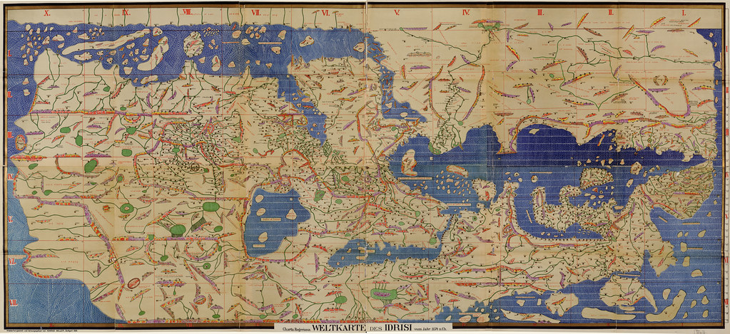
Maps have not always shared today’s usual orientation. The reconstructed world map produced by al-Idrisi in 1154 places south at the top, an arrangement found in medieval Islamic cartography. Chinese mapping and astronomical traditions have also used orientations that can look inverted to readers accustomed to modern Western atlases.
The practical lesson is more important than the historical novelty: up means north only after the map, its context, or a known convention establishes that relationship.
Even the word “orientation” points toward another possible reference. It is related to the east or “orient,” the direction associated with sunrise. Maps have been organized around sacred centers, coastlines, travel routes, astronomical views, and the needs of particular readers. No physical law required north to occupy the top edge.
Modern standardization still has a major advantage. When general-purpose maps consistently place north at the top, readers can compare two regions without first rotating one of them. North-up functions like shared grammar: it is powerful because people recognize it, not because north is objectively above south.
Position, heading, and map orientation are different things
These ideas are often blended together, although each answers a different question.
- Position describes where one place is relative to another. Portugal remains west of Spain however the page is turned.
- Heading describes the direction in which a person, camera, or vehicle is facing or moving.
- Map orientation describes which geographic direction has been placed at the top of a page or display.
Imagine a north-up map showing a road that runs north to south. A driver traveling south has east on the left from their own viewpoint, even though east remains on the right side of the map. Nothing is inconsistent. The map uses a stable geographic frame, while the driver uses a body-centered frame.
Moving between those frames requires mental rotation. The same process occurs when you stand in front of a city plan while facing toward the bottom of the diagram. You may understand the route perfectly, but you still have to convert “right on the map” into “left from where I am standing.”
Recognizing that conversion is useful because it identifies the exact source of confusion. The street has not changed, and neither has the map. The observer and the representation simply use different frames.
North-up and heading-up maps solve different problems
Digital navigation commonly offers two approaches. A north-up display keeps the geographic frame fixed while your marker turns and moves within it. A heading-up or track-up display rotates the map so that your current direction of travel remains near the top.
Neither setting is best for every task.
When north-up is useful
A fixed orientation preserves the overall structure of an area. Cities, coasts, and major roads stay on the same side of the screen even after you turn. This can make it easier to compare positions and remember that one destination is east of another across an entire journey.
North-up is well suited to questions such as:
- Which country lies northwest of the previous guess?
- Which region occupies the eastern side of a continent?
- How do several places seen at different times fit together?
Its cost is that the reader may need to rotate the map mentally before turning a cardinal relationship into an immediate left-or-right action.
When matching the map to your heading is useful
A heading-up display reduces that immediate conversion. If the road ahead also points toward the top of the screen, the map’s left and right more closely match the traveler’s left and right.
This is helpful for local action: choosing the next turn, identifying which path continues forward, or locating a building on the correct side of a street. The disadvantage is that the geographic frame moves whenever the traveler turns. A landmark that was on the right can swing toward the bottom of the display without moving in the real world.
A practical decision rule follows: north-up supports global structure; heading-up supports immediate action. Before interpreting a display, decide which type of problem you are trying to solve.
How orientation affects geography games
Orientation appears differently across Jueguecillos. It does not alter the games’ clues, but it can alter how we understand them.
In Globillo, keep directions geographic
When a clue provides direction, cardinal terms should remain the stable frame. If a target is northeast of a guess, that relationship does not depend on where you imagine the country on your screen or which route you would take to reach it.
A safe habit is to state the full geographic relationship first—“northeast,” rather than merely “up and right”—and then combine it with the distance clue. Cardinal language survives zooming, a change of device, and most changes in how we mentally picture the map.
There is another distinction to preserve. On an ordinary north-up map, a place shown higher usually has a more northerly latitude. That fact alone does not reveal the shortest route or the distance between the places. Orientation answers “which way?” Scale and geometry answer “how far?”
This matters most when several candidates lie in roughly the correct direction. The directional clue creates a sector, not a complete solution. Distance and previous attempts must still decide which parts of that sector remain plausible.
In Parejillas, the camera is not necessarily facing north
A road image presents a ground-level viewpoint rather than an oriented map. The top of the photograph means forward and visually distant, not north. Its right edge represents the camera’s right, not east.
Cardinal directions therefore should not be assigned without independent evidence. Shadows can sometimes contribute information about the Sun’s relative position, but interpreting them depends on time, date, latitude, and camera heading. A road extending toward the top of an image is simply receding from the viewer.
Begin instead with relationships inside the scene: the apparent driving side, the placement of road lines, the likely direction of vehicles, the slope, and the distribution of objects on either side. Only introduce a geographic orientation if the image supplies enough evidence to justify one.
This prevents a common reasoning error: taking a perfectly valid observation such as “the sign is on the camera’s left” and silently converting it into an unsupported statement such as “the sign is west of the road.”
In Viajecillo, rotating the map does not change the graph
A chain of land borders remains valid when the map is turned. Countries keep the same neighbors, and a route keeps the same number of border crossings. Viajecillo therefore offers a clean example of the difference between visual layout and underlying structure.
A candidate route may seem to travel the “wrong way” because it initially moves downward or sideways on a conventional map. That appearance does not prove the route is longer. The relevant test is the number of connections. A drawn map helps us remember adjacency, but the solution depends on borders, not on maintaining a smooth movement toward the part of the screen containing the destination.
This is especially useful near geographic bottlenecks. A shortest chain may have to move away from the destination visually before passing through the only available sequence of land connections. Counting edges protects the reasoning from the visual expectation that every step should look closer.
A four-step check for keeping your reference frame
Use this short procedure whenever you inspect a map, diagram, or geographic image.
- Find the reference. Look for a north arrow, coordinates, compass rose, or interface setting that reveals whether the display rotates.
- Name cardinal directions before screen directions. Replace “up” with “north” only after confirming the map’s orientation.
- Separate the view from the territory. Ask which way the traveler or camera faces, then separately ask where the depicted features are in geographic space.
- Choose one frame and keep it throughout the deduction. If you begin with north, south, east, and west, do not switch to left and right halfway through without performing the conversion.
One quick test is particularly effective: imagine rotating the screen by 90 degrees. Would your statement still be true? “Country A is east of Country B” should survive. “Country A is on the right” may not. The first describes geography; the second may describe only the current picture.
The idea that should survive when the map turns
North-up gives us a shared visual language, but its familiarity can hide the fact that every map is a deliberately oriented representation. South-up historical maps, rotating navigation displays, and ground-level road images all expose the same distinction.
Before making a deduction, identify what remains fixed. In Globillo, preserve cardinal relationships and distance evidence. In Parejillas, preserve the internal structure of the scene until an external reference is available. In Viajecillo, preserve border connections regardless of the direction in which the route appears to travel.
The final rule is concrete: state your conclusion in a form that remains true after someone rotates the map. If the conclusion collapses when the screen turns, it was probably describing the interface rather than the world.